

Land for Sale in Zimbabwe: What Your Agent Won’t Tell You About Land Productivity
If you’re searching for land for sale in Zimbabwe, you’ve likely been presented with the usual checklist: location, price per hectare, access to roads, and maybe proximity to a town. But what if I told you that the most critical factor determining whether your investment flourishes or fails is rarely mentioned in those glossy brochines or excited agent descriptions?
For years, the prevailing myth has been that all land is created equal-that an acre in Mashonaland is comparable to an acre in Matabeleland if the price is right. This dangerous oversimplification has cost buyers millions. The truth is, the soil beneath your feet, the invisible rainfall patterns above, and the land’s inherent productivity potential are the real determinants of value. This guide will equip you with the knowledge that most agents don’t have or won’t share, so you can move from gambling on dirt to investing with data.
Chapter 1: Soil Types Decoded - The Foundation of All Value
When you look at a plot of land, you see grass, trees, or crops. But a GIS analyst sees a complex story written in soil texture, composition, and history. The type of soil on your prospective purchase isn’t just about what will grow; it dictates construction costs, water drainage, and long-term stability.
The Three Pillars of Zimbabwean Soil
Zimbabwe’s soils are broadly categorized, and each tells a different investment story:
-
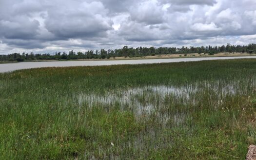
Clay Soils: Common in many parts of Mashonaland. They are nutrient-rich and hold water well, which is excellent for certain crops. However, they expand when wet and crack when dry. The hidden cost? Building foundations require specialized (and expensive) engineering to prevent cracking. Without proper drainage, they can become waterlogged.
-
Sandy Soils: Found in regions like parts of the Lowveld. They drain exceptionally well, which is a plus for construction. The drawback? They have poor nutrient and water retention. For agriculture, this means significantly higher irrigation and fertilizer costs—a recurring expense that eats into your ROI.
-
Loamy Soils: The gold standard. A balanced mix of sand, silt, and clay, loam offers good drainage, fertility, and workability. Land with deep, loamy soils often carries a premium price for a reason: it reduces risk and cost for both farming and development.
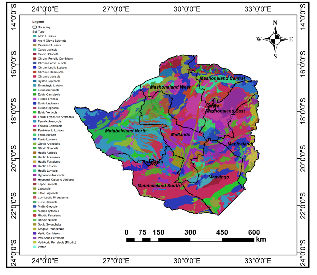
Before you commit, ask: “What is the dominant soil type, and how does that align with my intended use?” A dream home site on heavy clay needs a different budget than one on sandy soil, just as a maize farm’s viability depends on it.
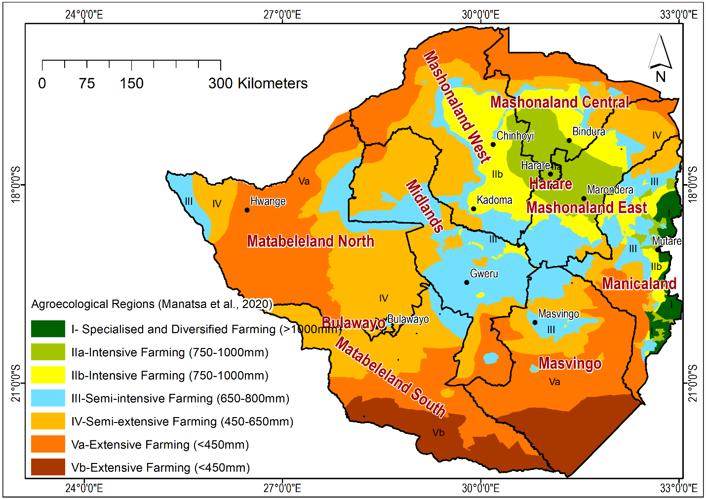
Chapter 2: Agro-Ecological Zones - The Climate Reality Check
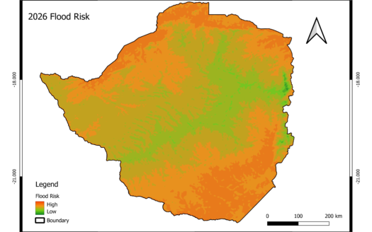
Location isn’t just about being close to Harare or Bulawayo. Its most crucial definition is agro-ecological. This classification, based on rainfall, temperature, and growing season length, is the single greatest predictor of what you can successfully do with a piece of land.
Zimbabwe is divided into five main agro-ecological zones (Natural Regions I-V), from the wettest to the driest.
-
Region I & II (High Rainfall): Ideal for intensive crop production (tobacco, maize, coffee). Land here is often priced at a premium for agriculture.
-
Region III (Moderate Rainfall): Good for maize and livestock, but carries more drought risk. Requires careful crop selection and water management.
-
Region IV & V (Low Rainfall): Primarily suited for extensive livestock ranching and drought-resistant crops like sorghum and millet. Attempting intensive cropping here without massive irrigation is a recipe for financial loss.

An agent might sell you a vast, beautiful tract in Region IV as having “huge farming potential,” neglecting to mention the consistent rainfall deficit. The map doesn’t lie. Your intended use must match the zone.
Chapter 3: Elevation & Slope – The Terrain Truths You Can’t Ignore
Elevation isn’t just about views. It’s a master controller of temperature, drainage, accessibility, and even construction cost.
-
High Elevation (>1200m): Cooler temperatures, lower disease pressure for some crops, but potential frost risk. Often more expensive to develop due to access and wind exposure.
-
Low Elevation (<800m): Warmer, potentially hotter, higher disease pressure in some areas, but often easier to access.
-
Slope Analysis: This is critical. A gentle slope (2-5%) is ideal for drainage and building. A steep slope (>10%) means:
-
Exponentially higher construction costs for cut-and-fill and foundation work.
-
Severe erosion risk if not properly managed.
-
Limited usable area for farming or building.
-
Key Question: Is that beautiful, affordable hillside plot actually 70% unusable steep slope? The elevation map tells the truth.
Chapter 4: The Productivity Score - Predicting Your True ROI
This is where it all comes together. Land productivity is a quantifiable measure of the land’s biological and economic output potential. It synthesizes soil quality, climate, topography, and historical land use into a single, powerful insight.
Think of it as a land’s credit score. A high productivity score for agriculture means the land can produce more yield with fewer inputs. For residential use, a productivity score might reflect landscape potential, drainage, and stability.
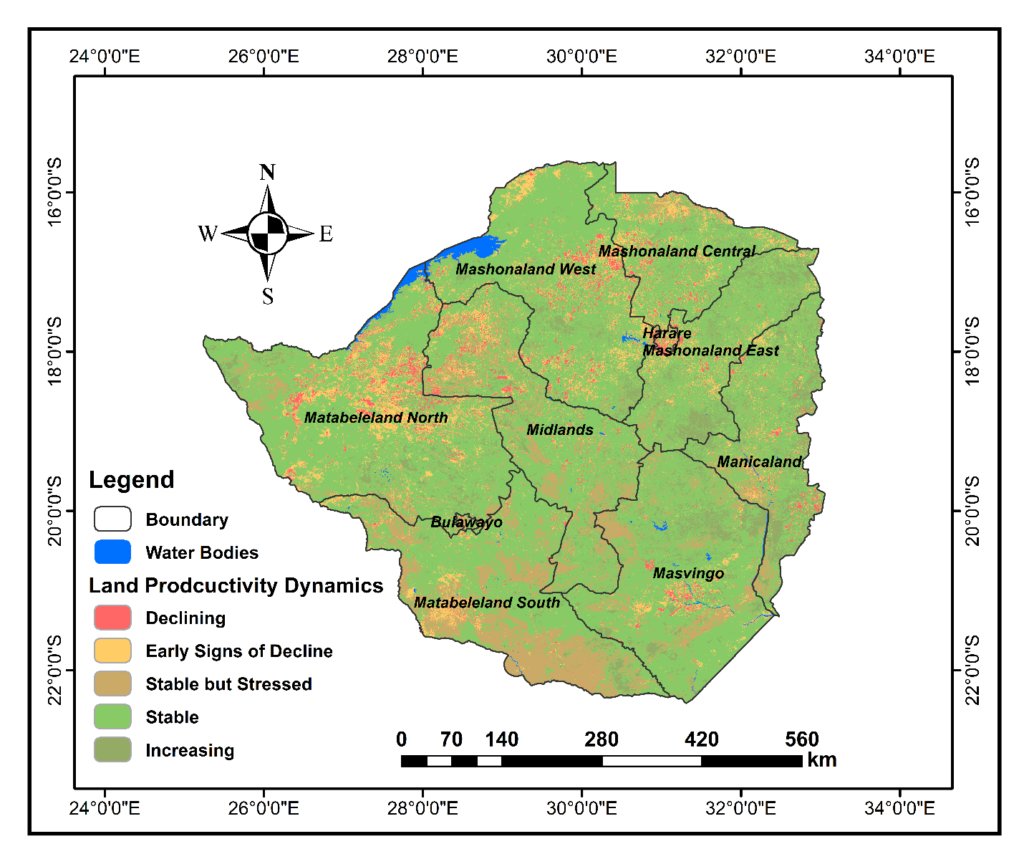
Why This Matters to You:
Two plots of land for sale in Zimbabwe, side-by-side and priced the same, can have wildly different productivity scores. One might be on a gentle, north-facing slope with deep loam (high score), while the other is on a compacted clay pan with poor drainage (low score). The high-score land will always be easier to develop, farm, and ultimately, resell.
Chapter 5: The Cost of Ignorance - When Data Is Missing
Let’s move from theory to the painful reality of what happens when these maps are ignored.
-
Case Study 1: The Diaspora Dream Home. A buyer from the UK purchased a stunning hillside plot near Mutare based on photos and a friend’s recommendation. He invested $40,000 in foundation work only to discover severe seasonal sliding due to the specific clay soil on that slope-a risk visible in a basic slope stability analysis overlayed with soil data. The fix cost another $25,000.
-
Case Study 2: The “Commercial Farming” Venture. A syndicate bought 200 hectares in a region bordering Natural Region IV, convinced they could grow wheat with centre-pivot irrigation. They didn’t cross-reference the agro-ecological map with historical borehole yield data. The groundwater was insufficient to run the pivots at capacity. The $150,000 irrigation system now sits idle, and the land is used for low-density cattle grazing at a fraction of the expected ROI.
These aren’t rare tragedies; they are weekly occurrences in the Zimbabwean land market. The cost isn’t just financial-it’s the loss of time, hope, and confidence.
Chapter 6: The Modern Due Diligence -Your Path to Certainty
Traditional due diligence involves checking title deeds and maybe visiting the site. For the modern, savvy investor, this is only step one. Modern due diligence is data-based due diligence.
This is where a service like Our Land Suitability Analysis becomes not an extra cost, but the most valuable part of your investment. Here’s what a professional GIS-powered report provides:
-
Parcel-Specific Overlay: We take your exact coordinates and overlay them on the very maps shown in this article—soil, agro-ecology, and productivity.
-
Risk Identification: We flag specific risks: “Plot is on Vertisol clay with high shrink-swell potential; foundation design must accommodate this,” or “Plot falls in Natural Region IV; confirm sustainable water source for intended irrigation.”
-
Suitability Scoring: We provide a clear score for your intended use: “This land is 8/10 suitable for orchard development but 4/10 for intensive vegetable farming without major irrigation investment.”
-
3D Terrain Modeling: Visualize your plot’s slope, aspect, and drainage pathways before you even set foot on it.
This process transforms an emotional leap of faith into a strategic, calculated decision.
Conclusion: Don't Gamble on Dirt. Invest with Data.
The search for land for sale in Zimbabwe is filled with opportunity, but it’s also mined with unseen risks. You now know that the three silent arbiters of value are Soil Type, Agro-Ecological Zone, and Land Productivity.
Agents sell plots. We empower you to understand them. In a market where information asymmetry is the norm, possessing this knowledge—and the tools to visualize it—is your ultimate competitive advantage.
Traditional due diligence involves checking title deeds and maybe visiting the site. For the modern, savvy investor, this is only step one. Modern due diligence is data-based due diligence.
This is where a service like Our Land Suitability Analysis becomes not an extra cost, but the most valuable part of your investment. Here’s what a professional GIS-powered report provides:
-
Parcel-Specific Overlay: We take your exact coordinates and overlay them on the very maps shown in this article—soil, agro-ecology, and productivity.
-
Risk Identification: We flag specific risks: “Plot is on Vertisol clay with high shrink-swell potential; foundation design must accommodate this,” or “Plot falls in Natural Region IV; confirm sustainable water source for intended irrigation.”
-
Suitability Scoring: We provide a clear score for your intended use: “This land is 8/10 suitable for orchard development but 4/10 for intensive vegetable farming without major irrigation investment.”
-
3D Terrain Modeling: Visualize your plot’s slope, aspect, and drainage pathways before you even set foot on it.
This process transforms an emotional leap of faith into a strategic, calculated decision.
See Your Land's True Story
Ready to move beyond the brochure? Stop guessing and start knowing.
Request a confidential Land Suitability Analysis from Us today. For a fraction of your potential risk, we’ll provide you with a professional, data-driven report that gives you the clarity to negotiate confidently, plan accurately, and invest securely.
Protect your investment. Define your future.