Land for Sale in Zimbabwe: What Your Agent Won’t Tell You About Drainage, Water Flow, and Development Risk
The First Rain Will Tell the Truth
You’ve found what looks like the perfect piece of land for sale in Zimbabwe. The price is right. The agent assures you it’s “prime property.” The grass is green, the views are stunning, and you’re ready to sign.
Then the rains come.
Within weeks, your “dream property” is a swamp. The road becomes impassable. Water pools around where you planned to build. The agent’s phone is disconnected. And you’re left wondering: Why didn’t anyone tell me?
If you’re searching for land for sale in Zimbabwe, this scenario is more common than you think. Every rainy season, buyers discover too late that their “perfect plot” sits on poor drainage, a seasonal wetland, or a flood path. The agent sold on a sunny day. Nature reveals the truth when it’s too late.
This guide changes that. Using professional GIS mapping, the same tools environmental authorities use, you’ll learn to read the land’s hidden water story before you commit a single dollar.
The Silent Killer of Property Value: Poor Drainage
When buyers evaluate land, they look at boundaries, road access, and price. Rarely do they ask: Where does the water go?
This oversight is costly. Across Zimbabwe, developers are increasingly forced to fund their own drainage and storm water infrastructure—costs that should be covered by municipalities but end up inflating property prices by 20-30% .
What are buyers really getting? A plot of land. And a long wait. Or worse, a stranded investment.
The Zimbabwean government has officially declared all mapped wetlands protected ecologically-sensitive areas under the Environmental Management Act. No construction or land clearing is permitted on a wetland without an approved Environmental Impact Assessment. Councils are prohibited from selling or approving land on such sites .
Yet agents continue to show properties on unserviced land. And buyers continue to lose their investments.
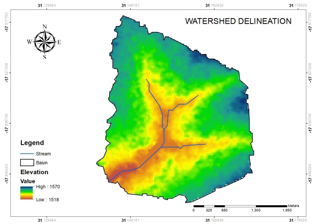
Watershed Delineation – Where Water Comes From and Where It Goes
A watershed is the natural drainage basin of a property. It tells you: Where does water originate? Where does it flow? Where does it exit?
The watershed delineation map defines the natural drainage boundaries of the property, revealing how water moves across the landscape. In the example below, the property has a total relief of approximately 52 meters, from 1,518 meters at the lowest point to 1,570 meters along the ridge, which creates sufficient gradient for efficient drainage without excessive erosion .
Stream channels originate along the highlands, flowing westward across the property. The watershed boundary follows the ridgeline, confirming that no external runoff enters the property from adjacent lands. This hydrological independence gives the buyer full control over water management, all surface water originates from rainfall falling directly within the property boundaries.
What this means for you: A property with a defined watershed boundary gives you predictable water flow. You know where water comes from and where it goes. There are no surprises from neighboring properties.
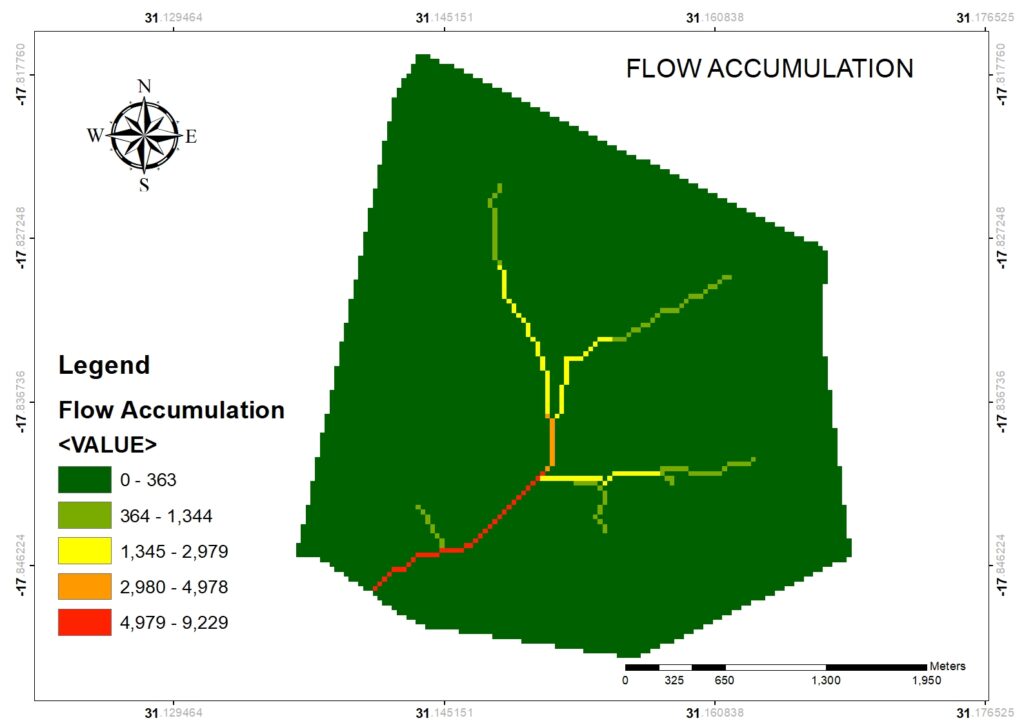
Flow Accumulation – Where Water Concentrates
Flow accumulation quantifies how water concentrates as it moves across the landscape. Each pixel value represents the number of upstream cells draining into that location.
Understanding the classes:
Lowest accumulation (0-363 cells): Ridge tops and upper slopes where water originates. These areas have minimal concentrated flow, making them the safest locations for building, roads, and infrastructure.
Moderate accumulation (364-2,979 cells): Midslopes and drainage swales. These zones require careful planning—they may experience intermittent flow during heavy rains and should not host critical infrastructure without proper drainage design.
Highest accumulation (2,980-9,229 cells): Primary drainage channels and stream courses. These are valley bottoms where water consistently concentrates. Development is strongly discouraged due to flood risk, erosion potential, and regulatory restrictions .
Research on land suitability in flood-prone regions confirms that areas far away from rivers and flood locations show the highest suitability for development, while areas near drainage channels require special consideration .
What this means for you: The safest building sites are on ridge tops and upper slopes with low flow accumulation. The most dangerous sites are in valley bottoms with high flow accumulation—exactly where agents often show you “flat, usable land.”
Identifying Wetlands Before Authorities Do
The Topographic Wetness Index (TWI) is what environmental authorities use to identify wetlands. It calculates where water accumulates based on the relationship between upslope contributing area and local slope gradient.
Understanding TWI values:
Negative values on this case study (-5.91 to -2.40): Dry, well-drained ridge tops and steep slopes. These are the driest areas on the property, highly suitable for development.
Moderate values (-0.5 to 2.41): Transition zones where water presence is seasonal. These areas may experience temporary wetness but dry out quickly.
Positive values (2.42 to 9.93): Persistently wet areas—wetlands, riparian corridors, and floodplains. These are protected zones where construction is prohibited .
Zimbabwe’s wetlands cover approximately 34.96 percent of the country’s total land area . The government has declared all mapped wetlands protected areas under the Environmental Management Act, and councils are prohibited from selling or approving land on such sites .
What this means for you: If your property has high TWI values, you are looking at protected wetland. No agent can sell it to you legally. No council can approve your building plans. Your investment would be at risk of demolition.
The Hidden Costs of Poor Drainage
Poor drainage doesn’t just make land unusable, it makes it expensive.
Developers across Zimbabwe are discovering that infrastructure costs are not covered by municipalities. Before construction can begin on many properties, developers must:
-
Install their own water and sewer systems
-
Build drainage and stormwater infrastructure
-
Drill boreholes and install storage tanks
-
Upgrade or build access roads
A developer building a mid-range townhouse might spend US$10,000–$15,000 per unit on municipal infrastructure, plus another US$5,000–US$8,000 on water storage, sewage, and electrical upgrades . These costs are passed directly to the buyer, inflating prices by 20-30% before profit margins.
When you buy land with poor drainage or without confirmed services, you are not saving money, you are deferring costs that will likely exceed the initial savings on the purchase price.